RGi is part of the winning team that was awarded the Better Buying Support Services (B2S2) IDIQ contract to provide the US Army Program Executive Office (PEO) Intelligence Electronic Warfare and Sensors (IEW&S) and their portfolio of Command, Control, Communications, Computers, Intelligence, Surveillance and Reconnaissance (C4ISR) programs with technical, program, operations, logistics, and engineering services in support of their current and evolving mission. RGi’s role will be to provide engineering services to improve and evolve how intelligence and sensor data is analyzed, disseminated, and visualized across the battlespace.
RGi will participate in the Medical Informatics Decision Assistance and Support (MIDAS) project, a SBIR Phase II contract funded by the Office of Naval Research (ONR) that will provide tools to generate recommendations for reducing the risk of musculoskeletal injury obtained during physical training. MIDAS will incorporate sensor data (e.g., wearable fitness trackers) collected during training, contextual knowledge (e.g., training plans, user biometrics, unit constraints), and machine learning to evaluate a trainee’s current state, assert a risk of injury score, and recommend mitigations that the individual and/or trainers can use to reduce the likelihood of injury. Throughout this project, RGi will provide support through use case development, technical implementation recommendations, and outreach to physical trainers and other stakeholders. This work will be performed under contract N68335-17-C-0044.
Categories
RGi wins follow-on DS TATs contract
RGi won a follow-on Defense Systems Technical Area Tasks (DS TATs) contract as a subcontractor to Alion Science and Technology in support of the PM Distributed Common Ground Station – Army (DCGS-A) Geospatial Intelligence (GEOINT).
DS TATs is a five-year, indefinite delivery/indefinite quantity (IDIQ) multiple award contract vehicle that allows RGi to focus on developing, testing and integrating the computational techniques and procedures that enable DCGS-A and Mission Command systems to provide real-time, geospatially correct Common Operating Picture (COP) which meets all requirements for sharing and reusing Geospatial and GEOINT in military operations.
Categories
OGC publishes RGi’s GeoPackage test tool
Following a comprehensive development and integration process, the Open Geospatial Consortium (OGC) published RGi’s GeoPackage test tool to integrate with its TeamEngine Suite. The tool is used for testing geospatial standards for GeoPackages and ensuring compliance across systems. OGC publicly released the tool through its website on January 16, 2017.
Categories
RGi’s Arismendi recognized by PM DCGS-A
RGi’s Andy Arismendi received special recognition by PM DCGS-A for his tremendous efforts during the Joint DCGS-A Increment 1/Release 1 Test Event that occurred in late 2016. Arismendi’s “professionalism, attention to detail, and can-do attitude” contributed to a successful test, the results of which will be incorporated into the JITC DCGS-A Increment 1 Release 1 Joint Certification Report.
RGi’s FalconVTTM sensor is in production after a successful four-month beta test at a general aviation airport. FalconVT sensors were placed on nine Airport and Fixed Based Operator (FBO) ground service equipment vehicles, including fuel trucks, mowers and operations vehicles. The sensors performed to design specifications across a variety of weather conditions during the test, and continue to operate at the airport.
The FalconVT sensors operate across the entire airport operating area (AOA) utilizing the FalconNetTM communications network over an open commercial spectrum. Unlike cellular solutions, FalconNet is independent of ongoing airport activities and can support communications for up to 2,000 sensors at an airport.
Using GPS technology, FalconVT sensors provide highly accurate, once-per-second update rates that meet the requirements of the FAA’s Runway Incursion Warning System Advisory Circular (AC No: 150/5210-25). The sensor is low cost, highly portable and operates across the entire AOA, including ramp areas, airport perimeters, taxiways, runways, etc. The first production units are due in Q1 2017.
For more information on the FalconVT sensor or the full FalconTM suite of products, contact [email protected].
 RGi was recently named as one of the 2017 Best Places to Work in Virginia. The annual list of the Best Places to Work in Virginia was created by Virginia Business and Best Companies Group.
This statewide survey and awards program is designed to identify, recognize and honor the best places of employment in Virginia, benefiting the state’s economy, workforce and businesses. The 2017 Best Places to Work in Virginia list is made up of 100 companies.
“We are thrilled to have RGi recognized as a Best Place to Work in Virginia, said Steve Gillotte, President & CEO. Our motto is to have fun reaching your professional, technical and personal potential, so it’s wonderful to know we’re doing right by both our customers and our employees.”
The final rankings will be announced at an awards luncheon on February 2, 2017 at the Williamsburg Lodge in Williamsburg, VA. For more information, visit www.BestPlacesToWorkVA.com.
To join RGi’s growing team, candidates can review current opportunities at www.rgi-corp.com/careers or send a resume to [email protected].
RGi, in partnership with a General Aviation (GA) airport and its fixed-base operator (FBO), has a pilot program underway for its innovative FalconTM suite of products. RGi’s Falcon provides a highly accurate sensor updating at once per second for each motorized and non-motorized ground surface equipment (GSE) of interest allowing us to collect, analyze and predict substantial data across the entire airport operating area (AOA) using our Edison Intelligence Infrastructure. Our large cross-airport data store enables us to learn the precursor sequences of various sensor feeds that lead to the degradation of airport surface operations, allowing Falcon to provide time-to-event and a confidence level of the event occurring enabling the operations manager the opportunity to proactively execute a corrective action.
RGi began its inaugural pilot in August 2016 with the goal of analyzing and optimizing the fueling and servicing of GA aircraft by the FBO, as well as airfield maintenance (i.e., mowing and plowing) performed by the airport. With three months of data now in hand and additional data being collected each day, Falcon will provide the framework for the GA airport/FBO to improve customer service while lowering costs and driving efficiencies.
An additional pilot is scheduled to begin with a larger commercial airport in December 2016. For questions on Falcon, please contact [email protected].
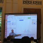 RGi’s Michael Szaszy, along with the US Army Corp of Engineers ERDC-GRL’s Dr. Ray Dos Santos, presented the Spatio-temporal Retrieval and Introspection of Data and Embedded Relationships (STRIDER) system on October 13, 2016 at the FedGeoDay Conference in Washington, DC.
Data processing and visualization is a highly challenging aspect of modern intelligence systems. As data volumes grow, the system must not only maintain a visual appeal, but also implement high selectivity (i.e., display only the least amount of the most relevant information). In this manner, the end user can focus on the task at hand rather than on the sifting of unimportant data. Szaszy and Dos Santos discussed STRIDER, a system that performs document reasoning helpful on various domains. STRIDER features location-enabled text parsing, machine learning techniques, and storylines. Internally, STRIDER performs data ingestion on both structured and unstructured data sources, making it available for many purposes: plotting documents on a map, building associations among spatial entities, and displaying numerical analysis, such as event correlation. In the visual interface, STRIDER uses a variety of multiple coordinated views, including maps, networks, and charts, to support data exploration and hypothesis testing workflows. STRIDER allows the analysis of complex data to be substantially enhanced through automation and mapping, and facilitates inferences on the underlying data points.
For more information on STRIDER, please contact [email protected].
The American Association of Airport Executives (AAAE) selected RGi’s Falcon product to participate in its inaugural Airport Innovation Accelerator Market Match program. Created by AAAE in 2015, the Airport Innovation Accelerator’s goal is to bring better solutions to the airport community more quickly through community, mentoring and services.
Falcon is a cost effective mobile and web-based solution providing highly accurate once-a-second tracking of up to 2,000 powered and non-powered ground service equipment (GSE) across the entire airport operating area (AOA). When deployed, the Falcon system:
- Displays the location of all moving assets on the AOA for both system users and vehicle operators for total situational awareness
- Provides real-time geofence alerts and metrics for system users and operators to manage by exception
- Conducts post analysis and historical replay of movements of all equipped GSE for rapid and complete forensic analysis.